
Roman Road: Via AppiaAntica (Appia Way) Geethapriyan Selvanayagam BA Landscape Architecture
Introduction
This is an argumentative essay based on Roman roads and there infrastructure.The researcher has given focus towards critical analysis of the research topic. In this study the researcher has used the past findings which are analyzed by various researchers. Roman roads were built from 300 BC ,during the expansion of the Roman Republic and the Roman Empire. Roman emperors gave huge consideration towards land transportation and for the movement of their armies, officials and civilians (Bull, et al., 2016). At the same time, for the purpose of inland carriage and trade of goods, roads were constructed by the Romans. Roman roads ranged from small roads to broad roads. At the same time, long-distance highways were also built by the Romans to connect cities, towns and military bases. Roman roads were mostly constructed using stone-pavers and metal, which were designed according to the drainage system. At the same time, footpaths, bridleways and drainage ditches also remained the focus area. Some of them were constructed while cutting through hills and by creating bridges over rivers. It is identified that the whole comprised length of Roman roads were 400,000 kilometers (250,000 miles), of which 80,500 kilometers (50,000 miles) were stone-paved. Additionally, in Gaul around 21,000 kilometers (13,000 miles) were improved from dirt tracks to stone paved roman roads. However in Britain only 4,000 kilometers (2,500 mi) were improved from the dirt track (Malkin, Constantakopoulou, &Panagopoulou, 2013). This is a stark comparison showing that the further you get from the centre of the Roman Empire the less developed it is. There are many Roman roads which have survived for millennium however some of them are overlaid by modern roads.
There are various Roman roads which exist at present toosuch as Via AppiaAntica. For this study, Via AppiaAnticaRoman road was selected by the researcher as this road still exists and it is open for the public. Wilson (2017) exhibits that the Appian Way was one of the earliest and one of the most important Roman roads for the ancient republic. This road is in southeast Italy and connects Rome to Brindisi.

Main Body
Via Appiais the Latin name and this road named Via Appia Way from the name of the person who was responsible for its construction and he was Appius Claudius Caecus. He was the Roman censor in the year 312 BC. In this time period he had get constructed the major parts of this road (Arslan, 2013). Arslan (2013) stated that the main routes of Appia way are used at present also. However, there are refurbished according to the modern age but still it is in original curve and links the same towns which it did in the past. AppiaAnticais the road which is still in use and very much beneficial for the Italian public. This road was constructed in 312 B.C. for military supplies and it was the main route for it. This was the first long road in Roman roads which was specially built for the purpose of transport troops. At the same time, Orengo (2016) identified that it is ancient property and it is essential to protect this ancient road, automobiles do not move on this road, there is a different road for the automobiles as they can dig the road. However AppiaAntica is one of the road which is in very good situation due to which it is used for the current purpose too.
Carreras,& De Soto (2013) stated that for the construction of AppiaAntica road, constructors have leveled the dirt road and after that small stones and mortar were laid on it. Finally, gravel was laid on it for tight fitting of stones and to interlocking the stones which has supported to provide a flat surface. Laurence (2016) argued that before the construction of this road valleys were filled and tall heights were flattened and also the bridges are constructed across the river for constructing the road as straight as possible. In this contest, Smith (2015) states that the stones of Appian Way are fit together in a manner that they appear to grown together securely and closely rather than fitted together. The stones of this road were stuck together in a manner that it is difficult to find out the joints. Smith (2015) exhibited that Appian Way was constructed by utilizing very advanced processes; this is the reason behind its existence till yet. This road was also cambered in the middle for the proper water runoff so water does not fill on this road during rain. Simultaneously this road had ditched on the side of the road and had protected by the walls. However, in the contrary, Laurence (2016) depicted that at present the surface of this road has become quite rough due to cement eradication in this time span. At the same time, its drainage ditches are also not working properly which were made on either sides and not become able to prevent from the situation of flood.
This road starts from Rome and finally reaches to Brindisi city and it is 350 mile long (Wilson, 2017). Bull, et al. (2016) identified that there are lots of interesting historical sites on the Appian Way and lots of tourist come to visit these places. Most of them are close to the city of Rome. Domine Quo Vadis Church is the first site from the city and this place has a believed that it is the place where Peter had seen the Christ. This is the main reason behind the probation of dead body could not be buried within the city. Most of the dead bodies were buried along the roads which were outside the city.
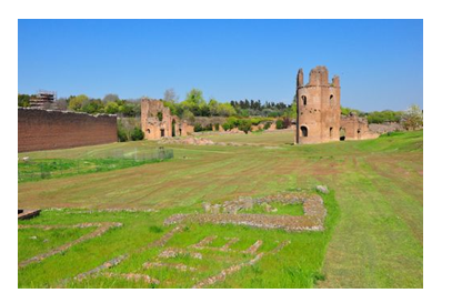
At the same time, there are entrances such as San Callisto, San Sebastiano, etc. which are the city’s catacombs along the Appian Way. Orengo (2016) identified that during the worst period of harassment even the Christians have laid their relatives dead bodies to rest at the Catacombs and also use these places as a meeting place. These catacombs are extended for miles and currently they are open for the public visit with the help of guided tours with the local monks and priests. In these catacombs early Christian art and ancient burial niches can be seen. St. Callixtuscatacomb is one of the greatest and most important catacombs. It had preserved many mosaics and frescoes and gives the evidence of burying the martyrs, Christians and popes in it. It is the road which has covered, hidden and protected various things and secrets in it. Various tombs can be seen on the road which was constructed by the important Roman people constructed tombs for their families. The shapes of these tombs are tiny to huge pyramid size. Circus of Maxentius is also the major site which is also located close to the city. There are signs along the road so finding these ancient sites is not a difficult task (Mócsy, 2014). Walking on the same road and stones which was constructed by Romans gives a special feeling. Moreover, visitors can also use bikes or bicycles for the rocky ride of this road. In support of this, Malkin, Constantakopoulou, &Panagopoulou (2013) depicted that the catacombs, tombs, mausoleums and villas of the Romans reflect the wealth and the status of Roman time.
Malkin, Constantakopoulou, &Panagopoulou (2013) states that the Appian Way hasn’t changed much and most of the ancient structures are just the same as they would have been 2,000 years ago. At the same time, the Via Appia Way has a stylish address which shows the wealth and stylish living of Romans. There are villas on this way which are still set off from the main road. In the contrary, Bini, et al. (2015) stated that there is a history of this road. Spartacus was the famous leader of Rome who has defeated many Roman armies and has made largest slave revolt. He has made every third person of the Italy a slave and was crucified in 71 BC with his 6000 followers and the bodies were lined in the 125 miles road from Rome to Capua. Hayek,& Caldwell (2014) identified that the best-preserved tomb along the Via Appia Way is the tomb of the Marcus Licinius Crassus’s daughter-in-law. He was the richest man of the Roman history.
However, this tomb was acquired by Pope Boniface VIII, in the early 14th century and after that it was turned into the fortress. At the same time, Hayek, & Caldwell (2014) depicted that it has the history of the early Christians who allowed their fellow Christians to worship and to bury them beneath their gardens of the villas which can be seen along the road. At the same time, Burnham (2015) depicted that Villa deiQuintili is a huge villa of Appia Way which was built by the wealthy Quintilii brothers in the 2nd century. This villa was so huge that when it was first dig out, people thought that it must have been a town. Emperor Commodus has killed its owners to death only for getting his own possession on this villa. This villa is not only big but was incredible too.
Bull, et al. (2016) exhibited that after the holding of Christianity in Rome, this road got a new life. There are various catacombs built beneath the road, and the bodies of Christian religion people were buried in them. After so many years still this road reminds the presence of Roman. Fulford (2014) stated that at that time, Romans were the masters of architecture and construction. Some of them were the very finest engineers. They had constructed the roads while focusing towards connecting all the roads to Rome. Mócsy (2014) depicted that Roman roads had played vital role in warfare and the success of the Roman army lied in the smart construction of the forts while focusing towards its strategically position. These forts have supported the army to get prepare for battle and to get quickly refresh and re-equip. additionally this stone-paved road remained supportive for the Romans for easy access and supply from Rome. However, Carreras, & De Soto (2013) identified that Romans were defeated from Samnite and their strategic construction not remained helpful to assist the Romans as they were get trapped in the mountains from the Samnites without supply.
On the other hand, Laurence (2016) exhibited that after a few miles there are several marble ruins, reliefs and broken statues which reflect sculpture art of the ancient Romans. Additionally, the ancient paving stones are visible more long at this part of the road. There is a ring road on the Via Appia Way and it is known as Grande RaccardoAnulare (GRA). However, at present recent improvement has taken place on GRA through constructing tunnel under the road which has supported to travel the road on foot for the distance of 16 km. At present, Via Appia has the longest stretch of total 62 km that is the straight road in Europe.
According to the views of Hayek, & Caldwell (2014) all these monuments remain assistive to attract the tourism and every year lots of people come to see AppiaAntica.
Conclusion
From the above study, it can be concluded that Romans have made amazing roads while utilizing effective techniques. These roads are so strong that they are present till yet after so many years too. In like manner, these roads reflect the stylish living and wealth of the Roman people. It also reflects believe and trust towards God as there is a presence of church. Presence of tombs and mausoleums reflects the knowledge of the Roman people. In like manner, villas and garden area supports to identify their intelligence in construction. Moreover, roads were built in a well-defined manner which assists to reflect technical advancement of that age. However, there are few shortfalls of the construction but still they are great. It is surprising to know that there is lots of advancement has taken place through our ancestors thousands of years ago. Underground catacombs are amazing to look and give the look to the martyrs, Christians and popes who were buried here. There are some improvements also taken place in the current scenario to make this road protected and preserved for the future context. This road is the reflection of our ancestors.
References
Arslan, M. (2013). Ancient routes, new destinations: Roman Road via Sebaste as a thematic cultural route. Mediterranean Journal of Social Sciences, 4(10), 660.
Bini, M., Rossi, V., Amorosi, A., Pappalardo, M., Sarti, G., Noti, V., …&Gualandi, M. L. (2015). Palaeoenvironments and palaeotopography of a multilayered city during the Etruscan and Roman periods: early interaction of fluvial processes and urban growth at Pisa (Tuscany, Italy). Journal of Archaeological Science, 59, 197-210.
Bull, P., Akrami, Y., Adamek, J., Baker, T., Bellini, E., Jiménez, J. B., …& Di Dio, E. (2016). Beyond: Problems, solutions, and the road ahead. Physics of the Dark Universe, 12, 56-99.
Burnham, B. C. (2015). Roman Roads in North-West Wales.By D. Hopewell.Gwynedd Archaeological Trust, Bangor, 2013. Pp. 84, illus. Price:£ 11.95. isbn 978 0 9927605 0 2. Britannia, 46, 436-437.
Carreras, C., & De Soto, P. (2013). The Roman transport network: a precedent for the integration of the European mobility. Historical Methods: A Journal of Quantitative and Interdisciplinary History, 46(3), 117-133.
Fulford, M. (2014).The Roman Period Research Agenda’. Hey, G. and Hind, J, 179-84.
Hayek, F. A., & Caldwell, B. (2014). The road to serfdom: Text and documents: The definitive edition. UK: Routledge.
Laurence, R. (2016). Connectivity, roads and transport: essays on Roman roads to speak to other disciplines?-ALCOCK SUSAN E., BODEL JOHN AND TALBERT RICHARD JA (edd.), HIGHWAYS, BYWAYS, AND ROAD SYSTEMS IN THE PRE-MODERN WORLD (The Ancient World: Comparative Histories; Wiley-Blackwell, Chichester 2012). Pp. xx+ 289, figs. 66.ISBN 978-0-470-67425-3.$134.95. Journal of Roman Archaeology, 29, 692-zzz695.
Malkin, I., Constantakopoulou, C., &Panagopoulou, K. (2013). Greek and Roman networks in the Mediterranean. UK: Routledge.
Mócsy, A. (2014). Pannonia and Upper Moesia (Routledge Revivals): A History of the Middle Danube Provinces of the Roman Empire. UK: Routledge.
Orengo, H. A. (2016). The Secret History of the Roman Roads of Britain.By MC Bishop.Pen & Sword, Barnsley, 2015. Pp. xiii+ 210, illus, maps, plans. Price:£ 19.99. isbn 978 1 848846 15 9. Britannia, 1-2.
Smith, A. (2015). Trevor Ashwin& Andrew Tester (ed.). A Roman-British settlement in the Waveney Valley: excavations at Scole 1993–4 (East Anglian Archaeology 152). 2014. xvi+ 254 pages, multiple colour and b&w illustrations. Dereham: Norfolk Historic Environment Service; 978-0-905594-53-8 paperback£ 25. Antiquity, 89(348), 1524-1525.
Wilson, P. (2017). Derventio, Delgovicia and Praetorio: Some Roman-Period Place-Names of Eastern Yorkshire Revisited. Britannia, 27-30.
